
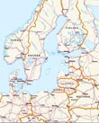
Map of Estonia
Estonia is bordered by Russia on the east and Latvia on the south. Its other borders are on the Baltic Sea and its extensions, with the Gulf of Finland in the north and the Gulf of Rīga in the west. Tallinn is about 80 km across the Gulf of Finland from Helsinki, the capital of Finland, and ferries run between the two capitals several times a day.
The land of Estonia is mostly a low-lying plain, with some hills in the central and southern regions. The average elevation of the country is only 50 m above sea level. The highest point in Estonia is a hill in the southeast called Suur Munamagi, which has an elevation of 318 m. It is also the highest place in the Baltic states.
Main cities: Antsla, Puka, Tartu, Tallinn capital and Viljandi.
|
|
Copyright © Geographic Guide - Travel European Continent. |
Map base: United Nations.