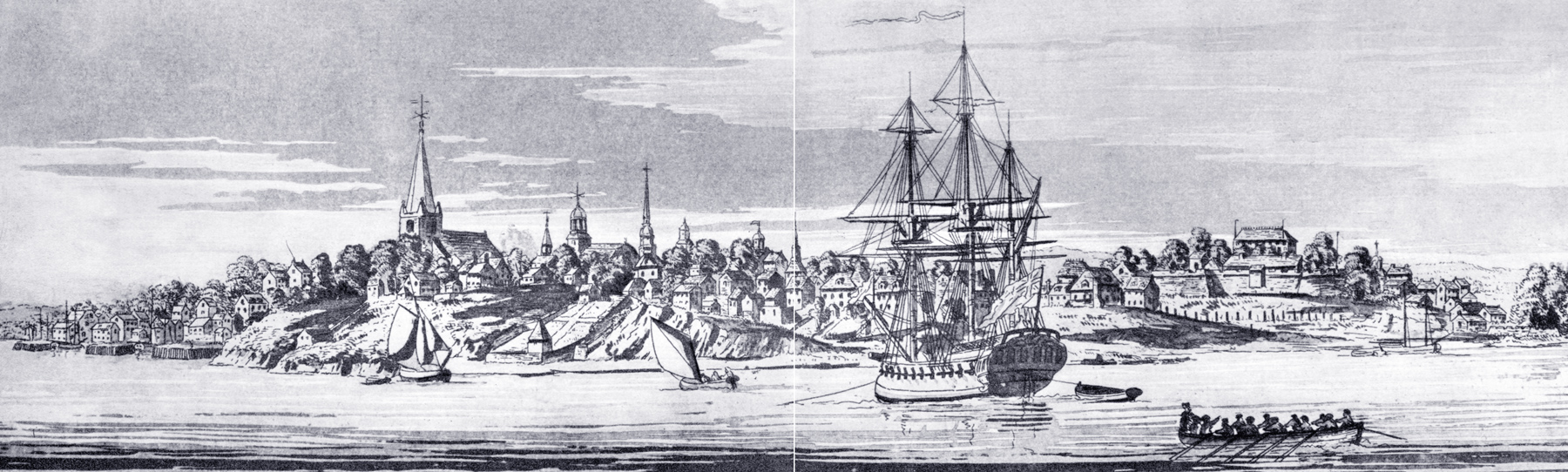
View of New York from Northwest - 1773
View of the City of New York from northwest, the large "Atlantic Neptune View" or the "Wooded Heights View". Aquatint, in sepia. Source: Isaac Newton Phelps Stokes (Iconography of Manhattan Island, ... 1915).
Continue below...
According to Stokes the date depicted is probably shortly before 1773. Date issued: probably 1777. Provenance: from the Atlantic Neptune (Impression supérieure), Vol. II, Pl. 112. Owner: Edward W. C. Arnold, Esq., who bought it at the sale of the M. C. D. Borden Collection (February, 1913).
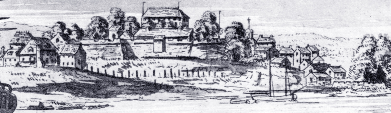
Still according to Stokes, «The view must have been drawn between 1763, when Des Barres first visited New York after his appointment as engineer in charge of the preparation of the Atlantic Neptune, and 1773, when the Governor’s House (Mansion House) in the Fort, which appears in the view, was destroyed by fire, this house never having been rebuilt inside the Fort. Although it has not proved possible to assign a definite date between these limits, the general appearance of the view in comparison with the various maps of the period seems to indicate that it was drawn shortly before 1773.»
Continue below...
|
Copyright © Geographic Guide - 18th Century NYC. Historic U.S.A. |
![]() «This
view is generally considered one of the most attractive and interesting
representations of New York in the eighteenth century. Although the height of
the bluff on which Trinity
Church stands has evidently been exaggerated (Broadway in front of the
church is actually only about thirty-five feet above high water), the contour of
the land is, nevertheless, probably more accurately depicted than on the
Carwitham or any other early view of the city. This is natural, as we know that
special pains to secure accuracy were taken in the preparation of the plates of
the Atlantic Neptune, which were intended primarily for military
purposes.
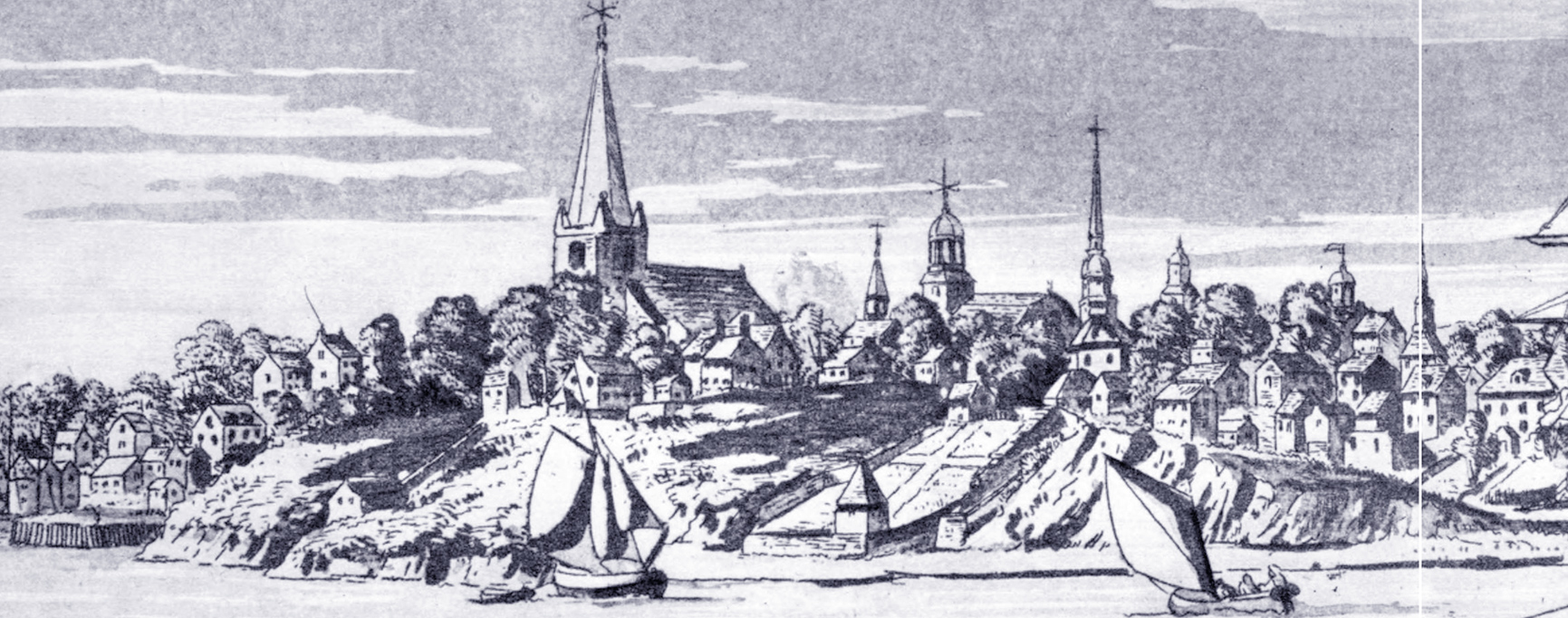
«This
view is generally considered one of the most attractive and interesting
representations of New York in the eighteenth century. Although the height of
the bluff on which Trinity
Church stands has evidently been exaggerated (Broadway in front of the
church is actually only about thirty-five feet above high water), the contour of
the land is, nevertheless, probably more accurately depicted than on the
Carwitham or any other early view of the city. This is natural, as we know that
special pains to secure accuracy were taken in the preparation of the plates of
the Atlantic Neptune, which were intended primarily for military
purposes.
The view shows very clearly the Fort and the buildings which it contained at this period. By a comparison with the Ratzen Plan (...), it is easy to recognise the principal buildings throughout the entire city. The little settlement at the extreme left clusters around Paulus Hook Ferry, which is the slip just south of King’s Wharf, the central of the three wharves seen in the view. The houses rising steeply one above the other in line with the most southerly of these three wharves are on Crown (Liberty), Little Queen (Cedar), and Stone (Thames) Streets. The church at the summit of the bluff is of course Trinity, just south of which, across Rector Street, may be discerned the building of the Free English School. The small steeple south of Trinity is that of the Lutheran Church, on Broadway below Rector Street. Next to this is seen the Middle Dutch Church. The positive identification of the next tower and steeple presents some difficulties. They are probably intended to represent the Wall Street Presbyterian Church, which we know from Smith’s History of the Province of New York (1757), p. 192, had a “Steeple” 145 feet high. Kalm, too, writing in 1748-9, says the church had a “steeple and a bell in it.” From views of the period, notably from the large view forming part of the Ratzer Map (...), and from the manuscript view made after the fire of 1776 (...), we know that the steeple of this church at this time was surmounted by a cupola, and not by a spire. Indeed, the only churches having pointed spires were Trinity Church, the old Lutheran Church on Broadway below Rector Street, and the South Dutch Church in Garden Street. The only other church having at this period a tall steeple or tower was St. George’s Church on Beekman Street, and, from a glance at the Ratzen Plan, it will be seen that from the point from which the view is taken it is not possible to bring this steeple into range with that of the Presbyterian Church, and, besides, the point of view is so low that the steeple of St. George’s could not have appeared above the cupola of the Presbyterian Church. Furthermore, the steeple of St. George’s differed materially from the representation in the view (...). "The most likely explanation seems to be that the tower and cupola of the Wall Street Church, which we know were tall and attenuated, have been erroneously depicted in this view, which perhaps was elaborated from a hasty sketch (...).»
Enlargements

Trinity Church
View of New York from Northwest - 1773