
Lower Manhattan - 1922
Aerial photo showing skyscrapers of the Financial District, Civic Center on the right, Seaport on the left and Two Bridges in the foreground, dated August 20, 1922. Source: Airscapes - New York City, Records of the Army Air Forces / U.S. National Archives and Records Administration.
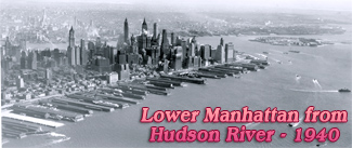
This is Lower Manhattan, looking southwest from the East River waterfront at Two Bridges neighborhood in New York City toward the Upper New York Bay. Hudson River is to the right. The Brooklyn Bridge is in the foreground and its terminal at Park Row is on the right. The Municipal Building is on the right.
The tallest building in the photograph is the Woolworth Building on Broadway (right) completed in 1913. It was the tallest building in the world when this photo was taken. At the time, the city's development was in full swing. In the first decades of the 20th century, the largest buildings in the world were built here. This dizzying growth slowed after 1929, with the Great Depression.
|
Copyright © Geographic Guide - 20th Century NYC Skyscrapers. |
Lower Manhattan - 1922