
From Duane Street (north) to Mail St. at Post Office.
Map of Park Row and Printing House Square - 1905
From Duane Street (north) to Mail St. at Post Office.
Map of Park Row and the Printing House Square in parts, Lower Manhattan, from Ann Street to Chatham Square. Published by Sanborn Map Company, insurance maps of N.Y., 1905. Source: Atlases of New York City from the New York Public Library.
These maps shows several other streets, including Lower Broadway, Nassau Street, Chambers St., Theatre Alley, Frankfort St., Centre St., Spruce St., Beekman St., Tryon Row and William Street. They include buildings and some of its architectural and construction details, street names and numbering, hydrants and much more. Map key with additional information is below.
Among the historic buildings, there are the City Hall, Post Office, Hall of Records, Court House, Times Building, Potter Building, Temple Court, Park Row Building, Beekman Building, Dennett's Coffee & Lunch Rooms, Clark Building, N.Y. Sun Building, N.Y. Tribune, American Tract Society, Brooklyn Bridge terminal, Metropolitan Realty Building, New Yorker Staats-Zeitung, German Herald Building, Rhinelander Building and more.
More maps from the same Atlas:
• Map City Hall Park and Lower Broadway in 1905 ►

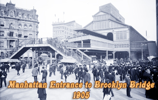
Park Row passed under the Brooklyn Bridge terminal.

From Post Office (north), Park Row to Cortlandt Street.


|
Copyright © Geographic Guide - Old NYC, 19th Century. Historic Maps |
Click on the maps to enlarge them.
Map of Park Row and Printing House Square - 1905
