North East Environs of the City of New-York - 1757
Original title: A Plan of the North East Environs of the City of New-York performed by order of his Excellency the Earl of Loudon & cª. & cª. By Samuel Holland, 17th September 1757. Engraved for D.T. Valentine's Manual for 1859 by George Hayward. The original plan was in possession of the State Library, Albany, N.Y. and was destroyed by fire in 1911.
This is a hand colored map (source Columbia University) from the original black and white drawing in the State Library of Albany, now New York State Library. It shows fortifications, buildings, farms and private gardens in rural Manhattan in 1757. Relief shown by hachures. Enlargements on the right.
Samuel Holland (1728-1801) and William Gerhard de Brahm were appointed in 1764 respectively as Surveyor-General in the northern and southern North American districts, provided additional material in updating British maps through surveys of land areas.
John Campbell, 4th Earl of Loudoun was sent to North America, in 1756, as Commander-in-Chief and Governor General of Virginia and commander in chief of the British forces in North America. He arrived in New York on July 23, the same year. He was back in Scotland, in 1763.
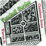
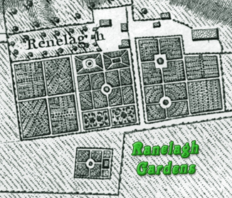
The map shows, for example, the Rutger's farm with the Widow Rutgers’s brew house. The place became the Ranelagh Gardens in 1765. The palisades, block houses and four gates were constructed in 1745.

North East Environs of the City of New-York - 1757

Ruins of the Battery near the Hudson River.


|
Copyright © Geographic Guide - Rural Manhattan, 18th Century NYC. |
Enlargements of the map above.

The palisades were removed in the 1760s.