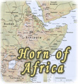
Map of Ethiopia
The Federal Democratic Republic of Ethiopia is a country in northeastern Africa. It is bounded on the northeast by Eritrea and Djibouti, on the east and southeast by Somalia, on the southwest by Kenya, and on the west and northwest by Sudan. A high plateau capped with rugged mountains covers much of Ethiopia; lowland deserts surround the plateau region.
Known as Abyssinia until the 20th century, Ethiopia is the oldest independent nation in Africa. It was home to the powerful Christian kingdom of Aksum that flourished from around the first century AD. After the 16th century, Ethiopia divided into a number of small kingdoms, which were reunified by Menelik II in the 1880s. Eritrea, which had been part of Ethiopia since the 1950s, became an independent nation in 1993 after a civil war.
Addis Ababa is Ethiopia’s capital and largest city. It was established in 1889. Major urban migration into the city began in the 1970s, driven mainly by unemployment and declining agricultural productivity in the rural areas.

|
Copyright © Geographic Guide - Travel African Continent. |
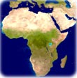
◄ Africa
Map (edited): U.S. Central Intelligence Agency, 2000 (Physiography).
Map of Ethiopia