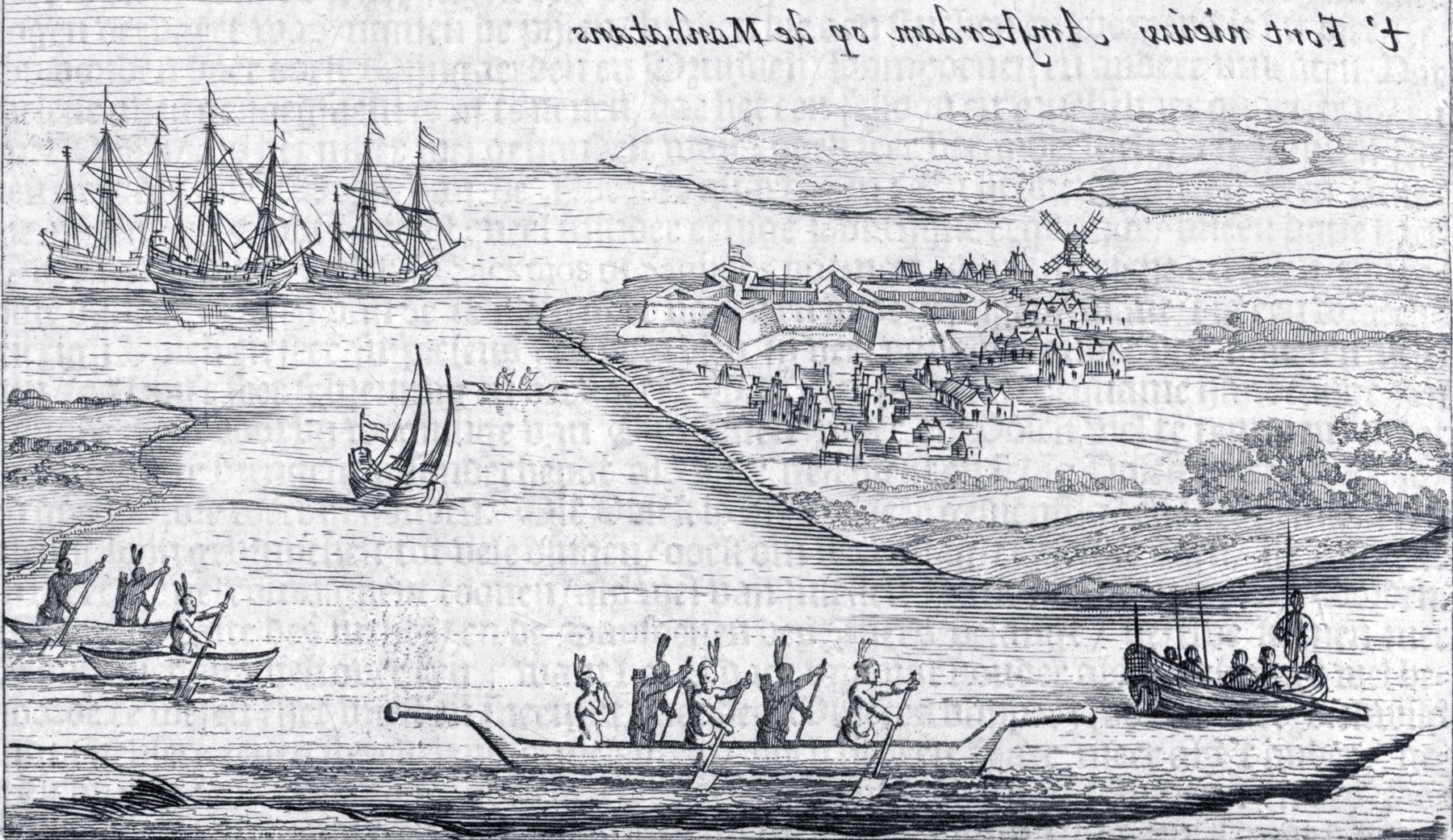
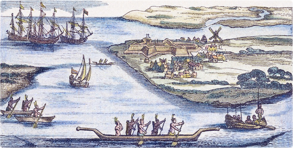
T'Fort Nieuw Amsterdam op de Manhatans - between 1626 and 1628
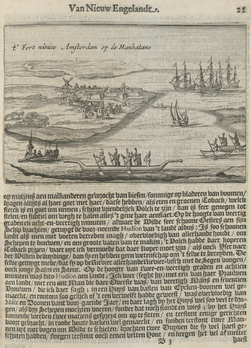
Original title: t’ Fort nieuw Amsterdam op de Manhatans, known as the "Hartgers View". The image above was transformed (reversed) from the image on the right, from the I. N. Phelps Stokes Collection of American Historical Prints, New York Public Library. It was engraved on copper and published by Joost Hartgers, Amsterdam, in 1651, in Beschrijvinghe Van Virginia, Nieuw Nederlandt (etc.). Author: perhaps Kryn Frederycks (Cryn Fredericxsz). Year depicted: 1626-1628 ?
![]() According
to Phelps Stokes (Iconography
of Manhattan Island, ...1915), This is the «Earliest
impression of the only known state. A later impression, from the same plate, and
without any change, was used in Vander Donck’s Beschryvinge Van Nieuw
Nederlant, etc., Ist edition, 1655, p.9. This picture, if authentic, is the
earliest known view of Manhattan Island. Its authenticity, however, has been
seriously questioned, and it is supposed by some to owe its origin to the
fertile imagination of Joost Hartgers, and to have been concocted in the “tiny
back parlor” of his shop on the Dam, purely as an embellishment for his little
quarto volume. If, however, we accept the theory that the view has been
reversed, the topographical features become so suggestive of reality that it
seems much more likely that it actually had some basis in fact; and perhaps the
most tenable theory is that it was intended mainly to show the Fort as
originally projected, or, as is even more likely, to depict a proposed but never
executed design, abandoned prior to the reconstruction of the Fort in stone with
four bastions, commenced by Minuit in 1628, when the settlement, grouped about
the Fort, was beginning to assume some little importance. It cannot have been
drawn after the completion of the Fort, for it shows a fifth bastion to the
south which was never built, although in The Representation of New Netherland,
1649 (in Jameson’s Nar. N. Neth., 331), it is stated that “From the first
it has been declared that it [the Fort] should be repaired, laid in five angles,
and put in royal condition.” Moreover, we know from repeated references in the
early records that the Fort, even at a much later period than 1628, was little
more than a sodded earth-work.
According
to Phelps Stokes (Iconography
of Manhattan Island, ...1915), This is the «Earliest
impression of the only known state. A later impression, from the same plate, and
without any change, was used in Vander Donck’s Beschryvinge Van Nieuw
Nederlant, etc., Ist edition, 1655, p.9. This picture, if authentic, is the
earliest known view of Manhattan Island. Its authenticity, however, has been
seriously questioned, and it is supposed by some to owe its origin to the
fertile imagination of Joost Hartgers, and to have been concocted in the “tiny
back parlor” of his shop on the Dam, purely as an embellishment for his little
quarto volume. If, however, we accept the theory that the view has been
reversed, the topographical features become so suggestive of reality that it
seems much more likely that it actually had some basis in fact; and perhaps the
most tenable theory is that it was intended mainly to show the Fort as
originally projected, or, as is even more likely, to depict a proposed but never
executed design, abandoned prior to the reconstruction of the Fort in stone with
four bastions, commenced by Minuit in 1628, when the settlement, grouped about
the Fort, was beginning to assume some little importance. It cannot have been
drawn after the completion of the Fort, for it shows a fifth bastion to the
south which was never built, although in The Representation of New Netherland,
1649 (in Jameson’s Nar. N. Neth., 331), it is stated that “From the first
it has been declared that it [the Fort] should be repaired, laid in five angles,
and put in royal condition.” Moreover, we know from repeated references in the
early records that the Fort, even at a much later period than 1628, was little
more than a sodded earth-work.
There is a further reason for assigning a date not later than 1628 to this view. Michaëlius, in his letter of August 8, 1628 (in Versteeg’s Manhattan in 1628, p. 69), says: “They are cutting wood and erecting another mill, for the purpose of exporting to the Fatherland whole cargoes of timber fit for building houses and ships”; and again, in his second letter, of August 11, 1628 (in Jameson’s Nar. N. Neth., 131), “They are making a windmill to saw lumber and we also have a gristmill.” These two mills, one a saw-mill and the other a grist-mill, are without doubt those shown on the Manatus maps of 1639 (...), and are both there indicated as wind-mills.
As it is clear from the Michaëlius letters that the grist-mill was the earlier of these two mills to be built, and that the saw-mill was not finished on August 11, 1628; and, as we know from The Representation of New Netherland (in Jameson’s Nar. N. Neth., 326), as well as from other sources, that the former stood near the north-west bastion of the Fort, where the single wind-mill in the Hartgers View is shown, it is evident that, if this view depicts any particular period, it must be before August 11, 1628. ...
It is quite possible, and even probable, that the view from which this plate was made was drawn for Minuit by Kryn Frederycks, the engineer sent out in April, 1625, by the West India Company, “with particular instructions charging him with the construction of a fortification as well as houses in such suitable places as might be discovered by the Council” in New Netherland.[I]
![]() [I]
A contemporary copy of these original instructions,
sold with other papers of New Amsterdam interest by Frederik Muller & Co. of
Amsterdam, in 1910, is now in the possession of Mr. Henry E. Huntington. ...
Although it has not proved possible to secure access to these papers, which have
been in storage since their purchase, the following brief summary of the
“Instructions for the building of the Fort and Town in the New Netherlands,”
procured for the author at the time of the sale by Mr. Stiles, of the firm of
Henry Stevens, Son & Stiles, gives an idea of their special interest and
importance to our subject. We must, however, remember that no specific location
is given for the Town and Fort, this being left to the discretion of those in
command in New Netherland. The Fort was to be four-sided, of which one side was
to face the water, but no definite position was assigned. The three sides facing
landward were to be surrounded by a rampart and moat, the dimensions of which
are given. A bridge over the moat was to give access to the Fort on one side,
but which side it is difficult to determine as the references were lettered to
correspond to an accompanying plan which was not attached to this copy of the
specification.
[I]
A contemporary copy of these original instructions,
sold with other papers of New Amsterdam interest by Frederik Muller & Co. of
Amsterdam, in 1910, is now in the possession of Mr. Henry E. Huntington. ...
Although it has not proved possible to secure access to these papers, which have
been in storage since their purchase, the following brief summary of the
“Instructions for the building of the Fort and Town in the New Netherlands,”
procured for the author at the time of the sale by Mr. Stiles, of the firm of
Henry Stevens, Son & Stiles, gives an idea of their special interest and
importance to our subject. We must, however, remember that no specific location
is given for the Town and Fort, this being left to the discretion of those in
command in New Netherland. The Fort was to be four-sided, of which one side was
to face the water, but no definite position was assigned. The three sides facing
landward were to be surrounded by a rampart and moat, the dimensions of which
are given. A bridge over the moat was to give access to the Fort on one side,
but which side it is difficult to determine as the references were lettered to
correspond to an accompanying plan which was not attached to this copy of the
specification.
All the male population were to be impressed into the work of building the Fort so that it should be completed as soon as possible. Indians were also to be employed and the sailors of the fleet, special rates of pay being given to the latter. Ten houses were to be built outside, under the wall, for the use of the architect and the foremen of the works. The dimensions and style of these houses are mentioned. A school, hospital, prison, and church were also to be built, and their dimensions are given. The Fort was to be named Amsterdam. A broad street was to lead down to one side of the Fort; and smaller streets, which were to be numbered, were to lead out of the broad street at regular intervals, the intervening ground to be used for growing supplies. The number of houses to be built on each street is stated and their general character and dimensions given. These instructions, as we know from other documents of the period, were never completely carried out.
The report of Isaac de Ragière (Rassieres), addressed to the Directors of the West India Company, and written in the fortress of Amsterdam on the Island of Manhattan, September 23, 1626 (item F of Muller’s 1910 auction catalogue of MSS. belonging to the Van Rappard Collection:—see note), has even greater importance, although it is of general historical rather than topographical interest. It relates to the state of the colony as it existed on the arrival of de Rassieres, who states that very little progress had been made with the building of the Fort, that the government of the colony was in a bad state, and that great insubordination existed, which he had been forced to repress with a firm hand. The fines and punishments inflicted are stated, as is also the fact that a fort was being built at Orange (Albany) for the protection of the colonists trading with the Indians. He emphasises the fact that a better class of colonists should be sent out by the company if better results are to be looked for.
About thirty houses can be counted in the view, which corresponds with the number mentioned by Wassenaer as existing toward the end of the year 1626 (Jameson’s Nar. N. Neth., 83). Wassenaer states that the counting-house was kept in a stone building thatched with reed. This building probably stood on what afterwards was known as the Marckveldt, at the corner of the present Whitehall and Pearl Streets. It was referred to in 1638 as having been destroyed some time previously. ... The counting-house may be the building with the stepped gable shown in the view, standing east of the south-eastern bastion of the Fort. This is the most substantial edifice in the view and occupies about the right location. Wassenaer, in the same passage, speaks of the other houses as being built “of the bark of trees,” and adds: ‘‘ The Director and Koopman live together; there are thirty ordinary houses on the east side of the river. ...” Writing on August 8, 1628, Michaëlius tells us: “A new fortress is in course of construction, not so much for protection against the savages ... as against enemies from abroad. They are meanwhile beginning to build new houses in place of the hovels and holes in which heretofore they huddled rather than dwelt.”
It is interesting to note the existence of a small group of houses standing approximately on the block between Battery Place and Morris Street, on the west side of Broadway, a spot which tradition has long identified with the site of the first houses built on the Island. ... It is also interesting to remember that at this period the horse-mill, in the loft of which the first church services were held, and in connection with which Wassenaer, writing in November, 1626, tells us that a tower was to be built to contain the bells brought from Porto Rico, was probably either still under construction or had just been completed.—Wassenaer’s Historisch Verhael (in Jameson’s Nar. N. Neth., 83-4) [Michaëlius does not refer to a church building, but says, “From the beginning we established the form of a church. ... Others had forgotten to bring their certificates with them, not thinking that a church would be formed and established here.”]. Nothing, however, has been found in the records to prove that the projected tower was ever added to the church. This tower has often been confused with the hayrick so clearly seen on the N. J. Visscher and other early views, where it appears just above and slightly to the left of the Stadt Huys. That this landmark was a hayrick and not a tower can be plainly seen by comparing its representation in the views referred to above with that of the hayricks clearly shown in several places on the Manatus Maps, Appendix, II. The character of these early Dutch hayricks is also very clearly depicted in etchings of the period by Rembrandt and others.
Notwithstanding the above reasons pointing to a date between 1626 and 1628, we must admit the strength of the arguments which exist for assigning a considerably later date to the original production of this view. For example, each feature of the little settlement as here depicted may be traced to some description contained in one or other of the writings upon which Hartgers drew for his text. ... It is undeniable, too, that the houses, as drawn, are much more substantial than we should suppose possible from the records of this period. It is also interesting to note the great similarity between the drawing of the canoes and Indians in this view and those on the map of “Nova Belgica et Anglia Nova” in Blaeu’s Atlas of 1635 (...), which similarity, coupled with the better draughtsmanship displayed in their delineation on the map, must be considered as strengthening the argument that, in this respect, the Hartgers view was a copy and not the original, although it is of course possible that both were drawn from a common original. It is also difficult to account for the river seen in the view emptying into the Hudson opposite the mill, as no river exists in New Jersey at this point, although in the unreversed view its position would correspond pretty closely with that of Bushwick Creek, on Long Island. Two small streams, known respectively as Horsimus Creek and Hoboken Creek, did exist in this vicinity, in New Jersey, and can be seen on the Ratzer Plan (Pl. 41). They, however, were not nearly so important as the river shown in the view.
It is evident that the view has been reversed, for we know that the Fort was on the west shore of the island and not on the east as here shown. This may, conceivably, indicate that the picture was made by means of a camera obscura, as suggested by Mr. Innes (New Amsterdam and Its People, 2, Note 2), although it seems much more likely that it was carelessly engraved in Holland from the original sketch without reversing.
There are numerous process reproductions of this view, perhaps the best being that contained in Mr. William Loring Andrews’s New Amsterdam New Orange New York. The earliest reproduction is probably that included as a frontispiece in the second volume of Yates and Moulton’s History of the State of New York (1825). It is also reproduced by Asher, in his Essay.»
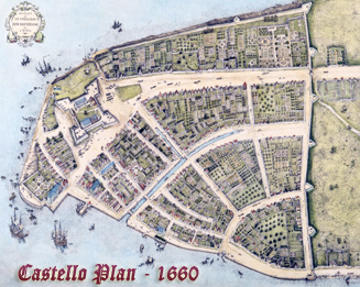
More: Maps of NYC - 17th Century ►
Copyright © Geographic Guide - 17th Century NYC. Historic Places


Inverted image

T'Fort Nieuw Amsterdam op de Manhatans - between 1626 and 1628