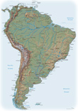
Map of Peru
Based on map from the Cartographic Section of the United Nations.
Peru is a country in west central South America. The capital is Lima, situated along the Pacific coast, a chief commercial center.
Peru was once the center of an extensive South American empire ruled by the Inca. This empire fell to conquerors from Spain in the 16th century. Attracted by the gold and silver mines of the Andes, the Spaniards quickly converted Peru into the seat of their wealth and power in South America. It remained a Spanish colony until the early 19th century.
El Misti Volcano, Arequipa Area, Peru (October 1988 - NASA). The large, multipeaked, snow-capped volcanic structure ascending more than 6055 m above sea level (center of the photograph) is Nevada de Chachani, directly north of which is the large caldera of an unidentified volcano. Southeast of Nevada de Chachani and across the Chili River valley stands El Misti Volcano, a dormant volcano that last erupted in 1870. El Misti (usually snow-capped, but not in this photograph), a cone volcano widely recognized in the Inca religion, has provided inspiration for Peruvian legends and poetry. El Misti rises 5825 m above sea level. Arequipa, one of Peru’s larger cities with a population of more than 100 000, sits along the western flank at the foot of El Misti. The city is located on a narrow plain and provides goods and services to southern Peru and northern Chile. Chief exports of this region are leather goods, textiles, foodstuffs, and wool.


|
Copyright © Geographic Guide - Travel American Continent. |
Map of Peru