
Images of Mediterranean Sea Area
Eastern Mediterranean Sea Area (below). The lands of the eastern Mediterranean Sea are featured in this spectacular, high-oblique, north-looking photograph. The island of Cyprus, near the center of the photograph, is partially obscured by dust; north of Cyprus is Turkey. The whitish object north of Cyprus and just north of the Turkish coast is Tuz Lake, a shallow, salt lake located in the middle of the Konya Plain of central Turkey. North-northeast of Cyprus is the Gulf of Alexandria, surrounded by the darker-colored Taurus Mountains. The coasts of Syria, Lebanon, and Israel are visible east and southeast of Cyprus. The dark-green Nile River Delta, bordered by the yellowish-orange sands of the Egyptian desert, can be seen along the coast west of Israel. The line just east of the delta traversing southward from the blue Mediterranean Sea is the Suez Canal. East of the canal, the border is a straight line between the brown vegetated lands of Israel and the brighter yellowish sands of the northern desert of the Sinai Peninsula in Egypt. Slightly east-northeast of the border are the pale blue waters of the Dead Sea. Cairo, Egypt, is the darkish-gray smudge near the apex of the Nile River Delta (NASA - June 1993).

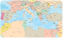
Countries
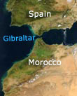
Mediterranean Sea and the Strait of Gibraltar photographed by NASA. Part of Spain can be seen above and Africa, below, in the photo.
Egypt

Smoke from fires in Greece can be seen drifting across the eastern Mediterranean Sea, in July 14, 2000 (NASA).


|
Copyright © Geographic Guide - Travel. |
Cyprus
