
Map of New York City by Longworth, Valentine's Manual - 1808
Original title: Plan of the city of New York, 1808. Text on print: Copied from D. Longworth's map of 1808 for D.T. Valentine's Manual for 1852. Lithographer George Hayward, 120 Water Street, New York. David Longworth (ca. 1765–1821) also published a map of New York City, dated 1817. More: Maps of NYC - 19th Century ►
In the early 19th century, the Common Council of New York promulgated regulations to keep streets clear and to require new streets be approved in advance.


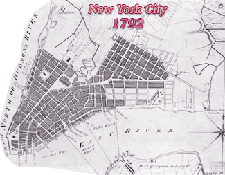
Map of New York City by Longworth, Valentine's Manual - 1808
|
Copyright © Geographic Guide - Maps of 19th Century NYC. |