
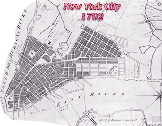
Goerck-Mangin Map of New York City - 1799
Title and other text on print: Plan of the City of New York, drawn from actual survey by Casimir Th. Goerck and Joseph Fr. Mangin, city surveyors, dated November 1803 (issued). Year depicted: 1799. Engraved from original map by G. Hayward for D.T. Valentine's Manual for 1856. A copy of the original map, dated November 1803, is shown further down this page.
Stokes (Iconography of Manhattan Island, ...1915) published an earlier version of this map, dated 1800, title (on the right): A Plan and Regulation of the City of New-York, etc. by the same authors Goerck and Mangin. It was engraved on copper by Peter Maverick, who was paid for printing copies of the City map, on December 5, 1803. Stokes also wrote:
On December 11, 1797, the city contracted with Messrs. Goerck and Mangin, City Surveyors, for a survey and plan of all the streets of the city (...). Before December of the following year Goerck died and the work was brought to completion by Mangin. On July 15, 1799, the map was ordered engraved “by Mr. Maverick or other competent persons.”
In the Minutes of the Common Council, under date of November 28, 1803, appears the following entry: ‘‘The committee, to whom was referred certain reports of the Street Commissioner on the subject of a plan for the future streets in the vicinity of the City, reported that the Map of the City lately printed and ready for sale contains many inaccuracies and designates streets which have not been agreed to by the Corporation and which it would be improper to adopt, and which might tend to lead the proprietors of Land adjacent to such streets so laid down into error.”
The committee resolved, therefore, to return the money paid by subscribers and to recall the map. They also requested that the Street Commissioner report to the Board at its next meeting ‘“‘what shall be proper to be printed and pasted on the face of such copies of the said Map as may hereafter be sold or distributed.” The paster added by order of the Common Council is as follows:" [see text in the lower right corner of the map on the right]
Continue below...
Continuation of Stokes' text started above:
"The N. Y. Hist. Society, ..., has two copies of this map, from one of which (here reproduced) the paster above referred to has been removed, disclosing the original title, which reads: ‘‘A Plan and Regulation of the City of New-York, made from Actual Survey by Casimir Th. Gorrek [sic] and Joseph Fr. Mangin, City Surveyors by order of the Common Council, and protracted by Joseph Fr. Mangin, Anno Domini 1800.”
On January 3, 1804, the Common Council resolved: “That application be made to Jos. F. Mangin for the field book which by his contract he was to furnish to the Common Council with the map of the city made by him, and that he be required to insert as far as is practicable on the large map made for and furnished to the Common Council the descriptions and specifications which he contracted to do by his agreement with the Mayor, Aldermen & Commonalty on the 11th of December 1797.”” This perhaps refers to the original manuscript map, a search for which in the various city departments has so far proved unavailing.
The coat of arms of the city, in the medallion in the lower right corner of the plan, was no doubt designed by Mangin. It is one of the most beautiful representations of the city arms which we have, although some liberty has been taken in the treatment".
More: Maps of NYC - 18th Century ►
"This Plan shows the Wards of the City as lately altered by the Legislature and designates with accuracy most of the Streets, Wharves, Slips etc. lying to the Southward of a line beginning on the North River at Wall Street thence extending through said Street to Hudson Street, thence to Leonard Street, thence to Broadway, from hence in a line to Bayard St. through this street to Bowery Road, thence to Bullock St, and through this street to the East River. Except Brannon & Spring St, none of the Streets to the Northward of the line above mentioned have been ceded to the Corporation or have been approved and opened under authority they are therefore to be considered subject to such future arrangements as the Corporation may deem best calculated to promote the health, introduce regularity and conduce to the convenience of the City. New York, Nov. 1803".
Above, title of the original map dated 1800, published by Stokes (Iconography of Manhattan Island, ...1915).
Below, a version on the map dated November, 1803, as published in the Valentine's Manual for 1856. Map was cut to fit this webpage.


Color version of the same map.

Below, version from the New York Public Library, dated November 1803. Enlargement of the tip of Manhattan, below, on the right.


Goerck-Mangin Map of New York City - 1799
|
Copyright © Geographic Guide - Historic Cartography of 19th Century NYC. |