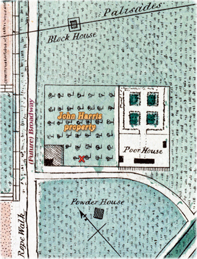
![]() The John Harris house was built
in the 1720s. It is believed to be the oldest house on
the Common, present City Hall Park.
The John Harris house is represented in the
Plan of James Lyne, 1728,
near the rope walk (now Broadway)
and the boundaries of the property are shown in the
Plan of the City of New
York in the Year 1735 as John ? Garden.
The John Harris house was built
in the 1720s. It is believed to be the oldest house on
the Common, present City Hall Park.
The John Harris house is represented in the
Plan of James Lyne, 1728,
near the rope walk (now Broadway)
and the boundaries of the property are shown in the
Plan of the City of New
York in the Year 1735 as John ? Garden.
According to Mark Cline Lucey (Documentary History of City Hall Park), the first known structure on the Common was a windmill built by two carpenters, Jan de Wit and Denys Hartogvelt, in 1663-1664. They received this plot of land, measuring twenty rods (approximately 100 yards) by twenty rods, from the Dutch West India Company. It appears that the John Harris property was part of this piece of land. He constructed a one-and-a-half story house (according to Lucey) at its southeast corner.
John Harris (?-1730) was a builder. In 1710, he and Isaac Anderson were chosen by the a committee appointed by the Common Council to rebuild the Great Bridge by the Custom house. In 1717, the City paid him "for bringing Several Boat Loads of Timber for Carriages, and Several Boat Loads of Sods, and for ferrying horses from Amboy to New York". His son, with the same name John Harris inherited the 1/4 part of the property in the Common, which included the house. He died in 1766.
In 1735, the Almshouse building (best known as the Poor House) was erected in the Common, on a plot adjoining the John Harris property (see map on the left). The Common Council ordered a garden to be fenced, plowed up, and kept for growing roots, herbs etc. In 1746 the City ordered an enlargement of the Almshouse and the fence with the Harris property was removed.
In 1745, in order to protect the City, palisades were constructed, in a zigzag pattern, across Manhattan Island, to the north of the Poor House. The palisades are represented in the Samuel Holland map, 1757.
John Harris died in 1730 and, according to Stokes (Iconography of Manhattan Island, ... 1915), his property was "248 feet square with a frontage on the east side of Broadway, the southerly line being just north of Murray Street. John Harris in his last will, made August 29, 1730, and probated August 13, 1734, bequeathed it to his wife, Jane (or Janitie) Harris. ... Jane Harris, in her last will, made August 3, 1734, and probated August 21, 1741, divided the property into four equal parts, on one of which stood the dwelling. This latter part she bequeathed to her son John, and one further part to each of three of her daughters, with life estates and reversions, a fourth daughter, Jane (Harris) Lynsen, participating merely in the part left to John Harris [son], in case he died without issue... By inheritance and purchase, William Peartree Smith, only child of Catherine (Harris) Pemberton, became seized of a ten-twelfths interest in the property, which he conveyed to the Corporation by Indentures of Lease and Release dated December 28, 1768... On September 7, 1769, the Corporation further acquired the interests of three of the six surviving children of Jane (Harris) Lynsen, the said six children having inherited a two-twelfths interest by reason of John Harris' death, intestate without issue, some time in 1766. This made the Corporation the owner in fee of eleven-twelfths interest in the property".
In 1770, the Common Council ordered that the old Harris house be “Let to such Gentlemen, professors of Physick & Surgery as have management and care of the hospital” (Minutes of the Common Council). The house was used for a laboratory.
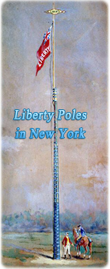
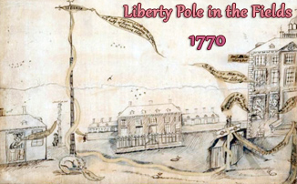
On February 3, 1770, Isaac Sears, member of the Sons of Liberty, acquired the twelfth share of the John Harris property, which the Common Council had not acquired, and erected fifth Liberty Pole with the help of his peers, on February 6. At that time, this piece of land belonged to Thomas Arden and wife. The fifth Liberty Pole was quietly taken down on October 28, 1776. Sears conveyed his interest in the plot to the City on October 19, 1785.
In 1775 the John Harris house was razed and the City built the Bridewell (prison) on the place for the “correction” of “the great number of vagabonds daily skulking about this city”.