
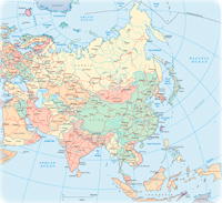
Asia
The largest and most populous of world's continents, considered as being divided from Europe by the Ural mountains and the Caspian Sea, the world's greatest lake in volume of water. The Isthmus of Suez connects Asia to Africa. The Asian continent shelters the highest elevation point in the Planet: the Mount Everest with 8,848 meters high, located in the border of China and Nepal. The world's largest metropolitan area is also located in Asia: Tokyo-Yokohama, in Japan, with more than 30 million people.
Asia, however, is more of a geographic term of secular tradition than a continent itself. Sometimes Asia is put in a bigger continent: the Eurasia, that includes Europe.
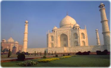
Taj Mahal, in Agra - India
The Taj Mahal was built between 1631 and 1648, by the Mogul emperor Shah Jahan (1627 - 1658) as a memorial and mausoleum to his wife, Mumtaz Mahal, also known as Arjumand, that died in 1631, because of childbirth complications. It is a magnificent architectural complex, comprising of a main gateway, a mosque, a garden, a guest house and the mausoleum.
Shah Jahan was deposed by his son Aurangzeb and imprisoned in Agra Fort until his death. He was later buried in the Taj, sharing the mausoleum with his wife.
The Taj Mahal is located in Agra, the old capital of the Mughal empire, north of India, about two and a half hours by train from New Delhi. It was designated a UNESCO World Heritage site, in 1983. Sea a map of India.
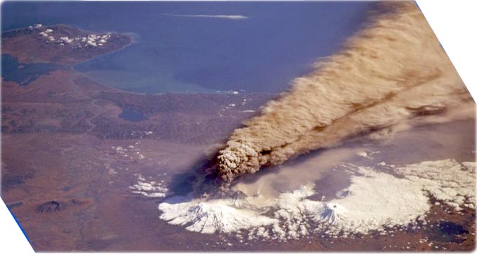
Klyuchevskaya Volcano, Kamchatka Peninsula, Russia (on October 1, 1994), Space Shuttle astronauts successfully took a series of photographs of Klyuchevskaya Volcano erupting near the east-central coast of Kamchatka Peninsula in Russia. This southeast-looking photograph was made as the spacecraft was approaching the volcano from the west. The dark, ash-laden plume rose to an estimated altitude of 10 to 14 km and drifted southeast of the volcano. Both lava and ash explosions occurred during this eruption. Klyuchevskaya Volcano is reported to be Kamchatka’s highest (4750 meters above sea level) and most active volcano. Small steam or ash plumes are also visible from subsidiary vents or craters immediately south of the major eruption zone. Other snow-covered stratovolcanoes appear in this complex cluster of volcanoes. The Kamchatka River Valley is seen in the foreground—first as it flows northward, then as it flows eastward, finally emptying into Kamchatka Bay. The blue waters of the Bering Sea are off the east coast of Kamchatka Peninsula (Photo and text by NASA).
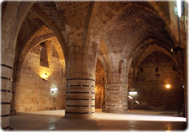
St. John's Crypt in the Hospitaller Quarter. The crusaders underground citadel in Acre, Israel.

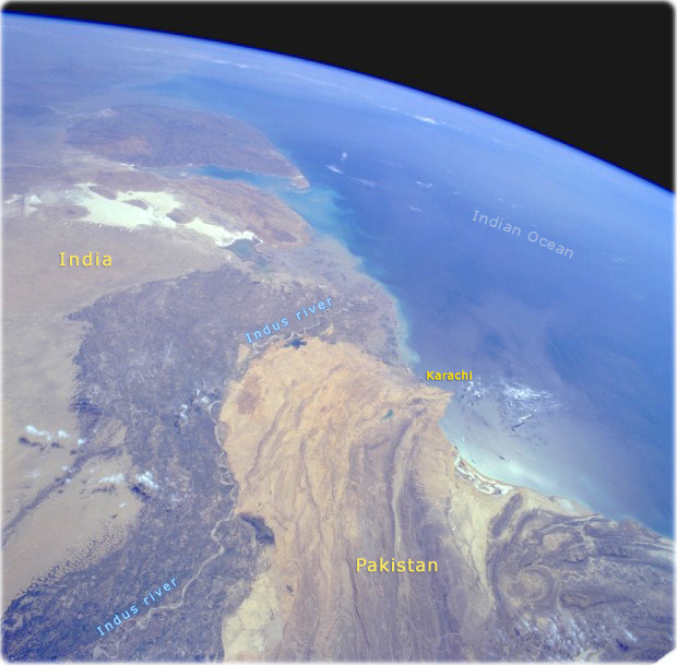
Indus River Valley, Pakistan (NASA, March 1994). Two major physiographic features appear in this south-southeast-looking, high-oblique photograph of southern Pakistan—the Indus River and its floodplain and the southeastern end of the complex Makran Mountain Range. The Indus River and its highly cultivated floodplain produce a variety of grain crops and cotton. Annual rainfall varies from year to year and usually does not exceed 50 cm, therefore, Pakistan, like Egypt with its Nile River, depends on the Indus River for water. The dark Indus River floodplain is bordered on the east by the Thar Desert (Great Indian Desert) and the highly reflective (white) area in India known as the Great Rann of Kutch (large salt marsh); on the west it is bordered by the complex, folded Makran Mountain Range. Karachi, the major port city on the Arabian Sea and former capital, is located along the western edge of the Indus River floodplain. The large peninsula southeast of the mouths of the Indus River is the Kathiawar Peninsula of India, the home of the only remaining Asian lions.
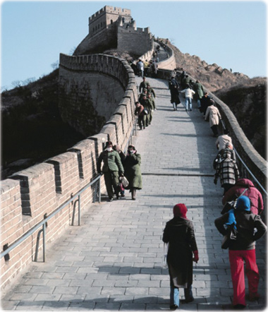
The Great Wall of China
|
About the Geographic Guide - Travel the world. |
Israel Ministry of Tourism
Asia

NOAA