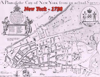
Plan of the City of New York, James Lyne - 1731
The Bradford Map
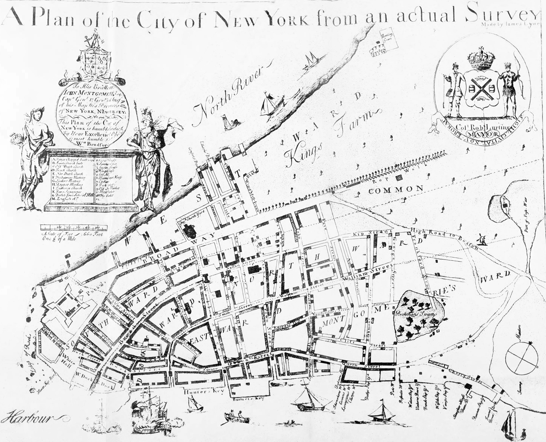
Original title: "A Plan of the City of New York from an actual Survey made by Iames Lyne". Copy of the original Bradford Map, so named by its owner William Loring Andrews. This historic map was published in the Andrews's book "The Bradford Map - The City of New York at the Time of the Granting of the Montgomerie Charter", in 1893 and again in 1900 in an "Appendix" for the same book.
William Loring Andrews (1837-1920) was born in Manhattan. He was a book collector, bookbinder and a writer, specially about the history of New York. In 1878, after retiring from his father's hide and leather business, he became a trustee of The Metropolitan Museum of Art and served as its first librarian. He was a founding member of the Society of Iconophiles of the City of New York, formed in 1894. Continue below...
William Bradford (1663-1752) was born in England where he learned the printer’s trade. In 1685, he opened a printing shop in Philadelphia. He moved to New York in 1693 and was appointed royal printer for the colony. On November 8, 1725, Bradford launched The New-York Gazette, the first New York newspaper.
The following text is an explanation about this map from Stokes (Iconography of Manhattan Island, ...1915):
Engraved on copper. Author: unknown. Date depicted: probably 1730. Date issued: probably 1731.
Engraver: unknown, but possibly Thomas Johnson, who engraved, about 1729, the Burgis Plan of Boston, which bears an ornamental dedication somewhat similar in character and execution to that on the Bradford Map. Another possible engraver is Charles Le Roux, the well-known silversmith and engraver, who, in 1715, 1716, 1719, 1734, and 1737 engraved bills of credit for the Province; those made in 1734 having been ordered delivered to William Bradford for printing, and who, on July 22, 1735, was ordered to make a seal of the Office of Mayoralty of the City of New York. Another possible assumption is that it was engraved by Francis Dewing, who arrived in Boston from England in 1715 and advertised his varied accomplishments in the Boston papers of the day. In 1722 he engraved and printed a large map or plan of “The Town of Boston in New England”, which much resembles the Bradford Map in general character and technique.
There are but two other copies of this plan known, one in the possession of the New-York Historical Society, presented to it by John Pintard in 1807, and one in the office of the Commissioner of Public Works (Bureau of Design and Survey; formerly the office of the Engineer of Street Openings). The latter is almost without doubt the impression formerly belonging to G. B. Smith, Street Commissioner, which was published in lithographic facsimile in 1834 by G. Hayward, which reproduction is also found in Valentine’s Manual for 1842-3.
This is of the earliest examples of the art of engraving on copper executed in New York, and almost without doubt the first plan of the city printed here. The earliest map engraved in New York was probably that published in 1724, also by William Bradford, in Papers Relating to an Act of the Assembly of the Province of New York, by Cadwallader Colden, “A Map of the Countrey of the Five Nations,” etc.
The plan was probably surveyed and drawn in 1730, and issued some time between February 11, 1730 and July 1st, of the same year. It was on the former of the last two dates that the Montgomerie Charter, defining the boundaries of the wards and creating “‘Montgomerie’s Ward,” was given over to the city, although the charter had been in preparation since March 23d of the preceding year. On July 1st occurred the death, at Fort George, of Gov. Montgomerie, to whom, as “Capt. Genl. & Govr. in Chief of his Majestis Provinces of New York, New lersey &c,” the plan is dedicated. It is almost certain, therefore, that it was drawn and engraved prior to this date, else the form of dedication would have been different. Colonel Robert Lurting, Mayor, whose name appears in the upper right-hand corner under the arms of the city, died on July 3, 1735.
Another indication that this plan could not, as has frequently been asserted, have been engraved, or even surveyed, as early as 1728, which date is found upon most of the early reproductions, is the fact that Bayard’s Sugar House, on the north side of Wall Street east of Federal Hall, is shown, and this building was not erected until a short time prior to August 17, 1730, on which date The New-York Gazette, in an advertisement, referred to it in such a way-as to indicate that it had just been erected. Proof that the date of issue was not later than 1733 is found in the fact that Cortlandt Street, laid out and named in the spring of that year, is not shown, as it almost surely would have been had the plan even been engraved after this date. Curiously enough, Cortlandt Street is shown on all the early facsimile reproductions of the plan except the first, issued by Longworth in 1817. Note, also, that the Bowling Green, laid out and named in 1733-4, is not found upon the plan.
The actual date depicted can with very little doubt be fixed at 1730. On August 13th of that year, a warrant was issued authorizing Cadwallader Colden, Surveyor-General, to “survey, for the corporation of New York, 400 feet beyond low water mark, on Hudson’s river, from Bestavers Killitie to the limits of the fort, from thence (leaving out, for the use of the fort, all the west side of the street that leads down to Whitehall) eastward along the East river, to the north side of Corlaer’s hook.” On September 15, 1730, the Common Council ordered the Treasurer to pay John Cruger the sum of forty pounds, “it being for the like sum by him disburst and paid to Cadwalladar Colden Esqr. his Majesties Surveyor General of this Province as a Reward for his fees and service for the Return of his Survey and Certificate thereof, for the New Charter and Grant to this Corporation.” This Warrant and Return are printed in full in Valentine’s Manual for 1856.
The appearance at about this time of Bradford’s Map, “from an actual Survey Made by Iames Lyne,” is significant, and suggests the possibility that Lyne may have been one of the surveyors engaged upon the survey of Cadwallader Colden who, as Surveyor General, probably did not personally take part in the field work. The fact that Bradford was at this time the provincial printer suggests also a possible official connection between his plan and the Montgomerie charter, although it is hardly likely that the Bradford Map reproduces, even in part, Colden’s survey, which, as we know from the Return, was not begun before August 13th, and was completed not later than September 2nd, a period of less than three weeks. We know, also, that its principal, if not its only object was to extend the boundaries of the city into the rivers and to determine the amount of land thus added, so that it probably contained no indication of the layout of the street system or other details of the city. Although it has not proved possible to connect the Bradford Map directly with the Montgomerie Charter or to assign to it an official standing, it is clear that it was at least a direct result of the interest aroused at this time in the boundaries of the city and in its redivision into seven wards, an interest which the enterprising Bradford did not fail to appreciate and take advantage of.
We have very little information concerning James Lyne. The first mention of his name that we find is in an advertisement in The"New-York Gazette of August 31-September 7, 1730: “On the 15th of September next at the Custom-House, in the City (where a convenient Room is fitted up) James Lyne designs to Teach in the Evenings (during the Winter) Arithmetick in all its parts, Geometry, Trigonometry, Navigation, Surveying, Guaging, Algebra, and sundry other parts of Mathematical Learning.” In 1737, Lyne was elected a constable of the West Ward, although he never served, as he was appointed Adjutant of Militia in October of the same year.
|
Copyright © Geographic Guide - 18th Century Maps, City of New York. |
The Manuscript Plan, Survey by James Lyne.
James Lyne map, redrawn for Valentine's Manual.

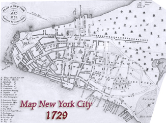
James Lyne Survey, version dated 1728.