Manuscript Plan of New York City, James Lyne
![]() Original title: "A Plan of the City of New York
― from Actual Survey made by James Lyne
― 1730". Wash drawing in pen and ink, and
color, on paper. The full map, from the New York Public
Library, is shown small at the bottom of this page. Enlargements were cut into parts to better fit
the page.
Original title: "A Plan of the City of New York
― from Actual Survey made by James Lyne
― 1730". Wash drawing in pen and ink, and
color, on paper. The full map, from the New York Public
Library, is shown small at the bottom of this page. Enlargements were cut into parts to better fit
the page.
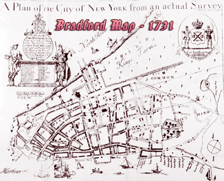
Explanation about this map from Stokes (Iconography of Manhattan Island, ... 1915): this map «was purchased, about 1880, from a junk-dealer in Nassau Street by Dr. Thomas Addis Emmet. In a letter to the author, dated May 15, 1910, Dr. Emmet states that the plan when found was badly torn and that he had had it repaired by George Trent. It is difficult to find a plausible explanation of the origin of this mysterious document, which may possibly be the original drawing, from which the so-called Bradford Plan (...) was engraved, perhaps even by the hand of William Bradford himself, in which case it would be one of the most important monuments in the cartography of New York. It will be noticed that the dedication bears the signature of William Bradford and an original seal [lower right corner]. A comparison of this signature with an authentic copy of Bradford’s discloses a close similarity, not sufficiently striking, however, to be conclusive.
The absence of a number of indications which are found on the engraved plan (...) would seem to prove that the manuscript plan was made at an earlier date, were it not for the fact that a careful examination of the former shows that the most important of these additions are in manuscript and exist only on the impression of the plan owned by Mr. Andrews... [see details in the Bradford Map].
On the other hand, the manuscript plan, while lacking other indications found on all the known impressions of the engraved plan, contains a number of features not found on the latter, which fact seems to indicate that the manuscript was not a mere copy of the engraving. The most prominent of these are the parking of the space around the Fort, the addition of the paths and trees in Trinity churchyard, and the appearance of a new building on the north side of Fair Street, west of Cliff Street. The Dutch school belonging to the Old Dutch Church on Garden Street, and the English school belonging to Trinity Church (references L and M) are shown on this map, and apparently are not later additions. As these two schools were not built until 1748-9 (...), it is clear that the map cannot have been made before that date, unless, contrary to appearances, these were added later. Why it should not show certain other changes which we know had taken place in the city between 1730 and 1748, we are unable to explain. For instance, in 1735, the Almshouse was built on the Common [it was completed in 1736, adjoining the John Harris house, that was built earlier and represented in the Bradford Map, but not here], and in the same year the new Half Moon Battery was erected south-east of the Fort (...). The completion of the platform for this fortification was celebrated by the roasting of an ox, whole, upon the Battery, and by “Firing and Drinking of the loyal Healths, by a great many People, as is usual on such Occasions.” —The N. Y. Weekly Jour., July 21, 1735. Another important building, erected during this period, was the Broadway, or Oswego Market, at Broadway and Crown Street (...).
It is also curious that the Bowling Green, laid out in 1733-4, should not be shown. The plan seems to show Trinity Church after the additions made in 1735-7, at least so far as the south aisle is concerned. Why the new north aisle, which the records show was built at the same time, is not shown, it is difficult to understand.
The discovery of these heretofore unnoticed manuscript additions to Mr. Andrews’s copy of the Bradford Plan removes the principal argument in favour of the priority of the manuscript over the engraved plan. Furthermore, a careful scrutiny of the former has revealed a partly erased inscription, probably a signature, in the left-hand lower corner, as well as the words “‘Made by J. Kall [or Kull, or possibly Katt or Kutt] Lon[don]” on the scale to the left of the scroll in the right-hand lower corner. The former it has not proved possible to decipher definitely, although Mr. Paltsits thinks he sees in the deleted inscription the words ‘‘ For the Commission, 1808.” [This would suggest that the plan was prepared, perhaps with others for the use of the Commission of 1807-11 (foot note)] This inscription and that on the scale, which is in gold, in minute block letters, had previously, for some inexplicable reason, escaped observation. An examination under the glass of the end of the scale, at the right of the scroll, reveals here also the existence, in the lower border, of some written characters. It proved impossible to decipher these until recourse was had to photography, when, after seventeen unsuccessful plates had been made, the eighteenth clearly revealed the figures 176— followed by either a “‘3” or a “5.” These figures are in a running hand and do not seem to have any connection with the original block-letter inscription. They probably, therefore, represent a later addition, and may have no significance.
From all of the above facts, perhaps the most plausible assumption would be that this mysterious manuscript plan was copied in London from the engraved map at some time after 1748-9, in which years the two schools which it shows (references L and M) were built, and that these two buildings were therefore included. Why these should have been added, and the other variations from the engraved plan which have already been referred to, should have been made, while several important changes which had occurred in the city between 1730 and 1748-9 were ignored, we have found it impossible to explain, except by supposing that the author of the manuscript was for some reason particularly interested in these schools.
A number of slight differences occur in the spelling on the manuscript and engraved plans, which seems to indicate a lack of knowledge of the correct names on the part of the author of the former. Thus we find on the engraved plan the name “Vanases Ship Yd,” which is erroneously written on the manuscript plan, “Van Cises Ship Yd.” “Wessels Ship Yd,” on the engraved plan, is called ‘‘Weeds Ship Yd” on the manuscript plan. ‘‘Vanderclifes Street,”’ correctly spelled on the engraved plan, is “Vanderclises”” on the manuscript. This is easily explained if we suppose that the “f” in Vanderclifes has been interpreted in the manuscript plan as an old-fashioned “‘s.” Vanderclifes Street later became Gold Street. “Frankford” Street on the engraved plan, is written “Frankfort” on the manuscript. ‘‘Frankfort” is found on the Ratzen Plan and continues with this spelling down to the present day. ‘‘Beekmans Street,” on the engraved plan, is changed to the more modern “Beekman Street,” on the manuscript plan. ‘‘Meal Market,” in the key of the engraved plan, is written ‘‘Meat Market” on the manuscript plan, an error which would not have been made by one with any knowledge of the city. Curiously, this same error is repeated on some of the facsimile copies of the engraved Bradford Plan. Note, also, that ‘‘Govenor,” in the manuscript, is thus spelled, in both the key and the inscription. ‘‘Montgomery” is written on the manuscript plan, in place of “Montgomerie” on the engraved plan, although, as we find both spellings used as early as 1734, there is no special significance in this difference, except that, generally speaking, ‘‘Montgomery”’ is the more modern spelling. Note, too, that “Hanover Sqvare” and “Qveen Street” on the engraved map become the more modern ‘‘Hanover Square” and “Queen Street” on the manuscript.
It is, however, still conceivable that the manuscript plan was a contemporary copy of the original Lyne survey, and that it was afterwards partly brought up to date; or that it was made in London, after 1748-9, perhaps in 1763 or 1765, and possibly from the original survey. That it served as the intermediary between the original Lyne survey and the engraved Bradford Plan, although conceivably possible, is, on the whole, unlikely.
(continue below)

![]() If
we accept the theory that the plan was made by or for William Bradford or by
someone else, and from the original survey, and that at some time subsequent to
1748-9 the two school buildings were added, without an attempt, in other
respects, to bring the plan up to date, we must suppose the name on the scale to
be that of the scale-maker, and the figures to be a later addition, and
therefore to have no special significance. It must, however, be admitted that
the character of the block lettering and the design of the frame or border
strengthen the argument that the manuscript was made at a date even later than
1763 or 1765, their style being suggestive of the last part of the eighteenth
century or the early nineteenth.
If
we accept the theory that the plan was made by or for William Bradford or by
someone else, and from the original survey, and that at some time subsequent to
1748-9 the two school buildings were added, without an attempt, in other
respects, to bring the plan up to date, we must suppose the name on the scale to
be that of the scale-maker, and the figures to be a later addition, and
therefore to have no special significance. It must, however, be admitted that
the character of the block lettering and the design of the frame or border
strengthen the argument that the manuscript was made at a date even later than
1763 or 1765, their style being suggestive of the last part of the eighteenth
century or the early nineteenth.
A very similar contemporary manuscript plan, preserved in the office of the Commissioner of Public Works, bears the date 1735 and the title “A Plan of the City of New York from an Actual Survey” (...). This plan is with little doubt a contemporary copy of the Bradford Map. To the lower edge of the map has been pasted a broad strip of paper, upon which is inscribed: “This Ancient Map Is respectfully Presented to The Honourable the Mayor and Common Council Of the City of New York By John Stanford A M 1828.” The directories show that at this time John Stanford was a minister, and resided at 13 Lispenard Street.
The existence on the manuscript plan here reproduced and on the manuscript plan preserved in the office of the Commissioner of Public Works, as well as on the engraved Bradford Map, of the two schoolhouses built in 1748-9, and the omission of all reference to other improvements made between 1730 and 1749, has not been explained except by supposing either that Mr. Andrews’s impression of the engraved map was copied from the manuscript plan here reproduced or from that in the Commissioner’s office, or that these plans were copied from each other or from the identical copy here reproduced of Mr. Andrews’s engraved map with the manuscript additions, and even this explanation is not complete or really satisfactory.»
|
Copyright © Geographic Guide - 18th Century Maps, City of New York. |
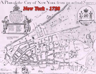
James Lyne, version dated 1728.
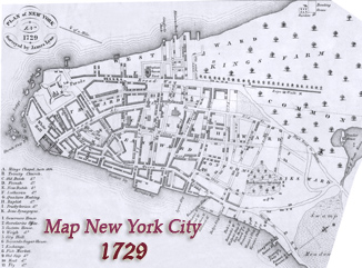
James Lyne map, redrawn for Valentine's Manual.

Year depicted: 1730, with additions after 1748. Made perhaps in 1763 or 1765.
Author: Unknown, made from a survey by James Lyne.
Manuscript Plan of New York City, James Lyne