New York City Waterfront - 1727
The Harbor of City of New York seen from Long Island in 1727. This is an inset from A Map of the British Empire in America with the French and Spanish Settlements adjacent thereto, by Henry Popple. It was originally engraved by Willm. Henry Toms (who also signed it) & R.W. Seale, issued in 1733. It was re-engraved by G. Hayward for D.T. Valentine's Manual for 1863. This copy is a reproduction of the copy from the Museum of the City of New York. Below, enlargements of the buildings from the copy from the New York Public Library.
According to Stokes (Iconography of Manhattan Island, ... 1915), "For a full description of this map, see Lowery Catalogue, No. 338. Winsor (Nar. and Crit. Hist., V: 474) states that Popple’s large manuscript draught is preserved in the British Museum, MS. 23615 (fol. 72), and that it is dated 1727. He also states that the first issue of Popple’s engraved map appeared in 1732".
References
A. The Fort.
B. The Chappel.
C. Secretary Office.
D. The Great Dock.
E. Part of Nutten Island.
F. Part of Long Island.
G. Dutch Church.
H. English Church.
I. The City Hall.
K. The Exchange.
L. French Church.
M. Ship Warfes.
N. The Ferry House.
O. Cattle Pen.
More: Maps of NYC - 18th Century ►

|
Copyright © Geographic Guide - 18th Century NYC. Historical Buildings of United States. |


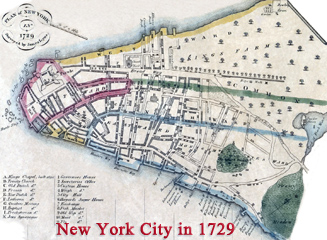

New York City Waterfront - 1727