
A Draught of New York and Perthamboy Harbour - 1752
This is an inset from the hand colored map "Particular draughts and plans of some of the principal towns and harbours belonging to the English, French, and Spaniards, in America and West Indies. Collected from the best authorities. By Eman. Bowen". From Emanuel Bowen's A complete atlas, or distinct view of the known world. 1752. Source: Library of Congress Geography and Map Division.
It is shown Manhatton, Perth Amboy Harbour, Sandy Hook, East Bank, Middletown, Staten Island, Utrecht, Hendricks, Flatland, Long Island, Copper Mine, Newark and Elizabeth Town.
More: Historical maps of New York City ►
|
Copyright © Geographic Guide - 18th Century NYC. Historical Maps of U.S.A. |

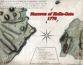


A Draught of New York and Perthamboy Harbour - 1752