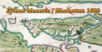
Map of New Amsterdam in 1660
The earliest known urban map of New Amsterdam and the only one dating from the period of the Dutch rule of New York. It is believed it was copied by an unknown draftsman around 1665-1670 from the survey made by Jacques Cortelyou (ca 1625–1693) in the summer of 1660, now lost. The map is commonly called the Castello Plan after the location in a Tuscan castle where it was discovered.
Original title (Dutch): Afbeeldinge van de Stadt Amsterdam in Nieuw Neederlandt ("Picture of the City of Amsterdam in New Netherland"). The original map is in the Biblioteca Medicea-Laurenziana of Florence, Italy.
More: Maps of NYC - 17th Century ►
Redraft of the Castello Plan - New Amsterdam in 1660. Authors: John Wolcott Adams (1874–1925) and I.N. Phelps Stokes (1867–1944). The Plan was redrawn by 1916. Source: New-York Historical Society Library.
At that time, New York had already taken on the form of a town, with a very active and prosperous municipal and commercial life.
More: Historical maps of New York City ►
More: Historical maps of New York City ►


|
Copyright © Geographic Guide - 17th Century NYC. Historical Maps. |
The Castello Plan
North is to the right.

The Castello Plan
Map of New Amsterdam in 1660