
Plan of the City of New York, 1755 - Duyckinck Map
Original title: "A Plan of the City of New York from an actual Survey, from an actual survey, anno Domini, M,DCC,LV", by Francis W. Maerschalck, city surveyor. Printed, engraved on copper and sold by G. Duyckinck. Owner: New-York Historical Society, presented in 1807 by John Pintard. Dedicated to James de Lancey "Lieutenant Governor and Commander In Chief In and over the Province of NEW YORK" and territories depending thereon in America.
Additional information from Stokes (Iconography of Manhattan Island, ...1915): Year depicted 1754. Other copies: Library of Congress (presented below in pieces), finest known, has an ornamental scroll border, of contemporary design but printed on separate strips. Trinity Church also possesses a copy and in rather poor condition, but complete. The only other recorded copy was destroyed in the State Library fire. Continue below...
Fragments of the copy in the Library of Congress.
|
Copyright © Geographic Guide - 18th Century Maps, City of New York. |
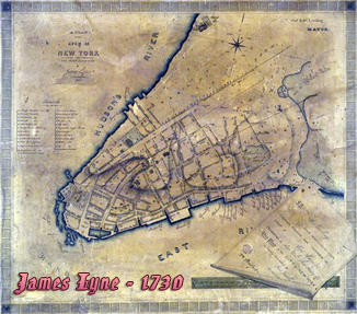
The Manuscript Plan, Survey by James Lyne.

Source: New-York Historical Society Collection, Norman B. Leventhal Map & Education Center, Boston Public Library.


Plan of the City of New York, 1755 - Duyckinck Map

![]() Additional
information from Stokes (Iconography of Manhattan Island, ...1915):
Additional
information from Stokes (Iconography of Manhattan Island, ...1915):
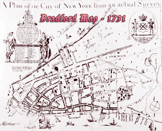
A microscopic comparison of this plan with the Bradford Map proves beyond the shadow of a doubt that the two were printed in part from the same plate. Du Simitiére, writing in 1768, notes this fact (Du Simitiére MSS. in Ridgeway Branch of the Library Company of Philadelphia). The plate, however, has been extended and very much altered, the joint being very easily distinguishable. The “P” of “Parade,” north of the Fort on the Bradford original, is here still distinctly discernible. Reference No. 10, the market at the foot of Wall Street, and reference No. 11, the market at the foot of Crown Street, show distinctly a lengthening toward the East River. This is also true of the slips in front of them. The water contours of the Bradford Map show plainly in the neighborhood of the little Bowling Green and Garden under “an” of the title of this plan. Note, among many other changes in the plate, that the lane just south of Trinity Church on the Bradford Map is not here shown. ‘This lane was closed in 1739, and a new street, Robinson (Rector), was opened in its stead a little to the south. Robinson Street is shown on the present plan. Rotten Row (Hunters Key) appears here for the first time on a map. This also is the first printed map to show the fortifications built in 1745, during the war with France. They are thus described by Smith in his History of the Province of New York (1757): ‘‘During the late War a Line of Palisadoes was run from Hudson’s to the East River, at the other End of the City, with Block-houses at small Distances. The greater Part of these still remain as a Monument of our Folly, which cost the Province about 8000l.’’
This map was advertised by Duyckinck in The New-York Gazette; or, the Weekly-Post-Boy, under date of March 3, 1755, as ‘‘shewing the several Wards, Streets, Lanes and Allies, Churches, Meeting Houses, Markets, Sugar and Distilling-Houses, Water Lots, with the additional New Lots &c &c. to this present Year. Done from an actual Survey.” Du Simitiére, in his notes on maps (book No. 1412 Y, Ridgeway Branch of the Library Company of Philadelphia), states that copies of the Maerschalck Map had become (even in his day) very rare.
A simplified copy of this map, on a reduced scale, was issued in 1763 as plate No. I of a collection of thirty engraved plans of American forts, published according to Act of Parliament, by Mary Ann Rocque, Topographer to His Royal Highness the Duke of Gloucester, in the Strand. The title of this copy, engraved at the top, is “A Plan of the City of New York, reduced from an actual survey by T. Maerschalckm 1763.” (The “‘m” engraved here as part of the name evidently stands for maker.) The map was engraved by P. Andrews and bears at the bottom the imprint of M. A. Rocque, near Old Round Court in the Strand. In a copy of this book belonging to Mr. Grenville Kane, the “3” in the date has been re-engraved as a “5.” A copy, in 1913 in the possession of Mr. Joseph F. Sabin, has the date untouched and bears no publisher’s imprint or address. [foot note: After this description had gone to press there appeared in a sale at Anderson’s, on April 9, 1915, a copy of this map, identical in every respect with the first copy here described, except that it had the date 1755 in the title].
This little book contains also a “Plan of the Narrows about 10 miles from N. Y,” showing the batteries, also the location on ‘‘Hated Island” (Staten Island) of a “Signal House proposed to receive y Signals from Sandy Hook and return them to New-York,” and the location of “‘Alarm Beacons which Serves at present.” The map of the city seems to have been issued separately, also, as a copy in the author’s collection has evidently never been folded. There are two copies of the little Rocque album in the N. Y. Public Library.
Among the old surveys in the office of Mr. Francis W. Ford, City Surveyor, is an original survey by Maerschalck, dated 1751, and showing the city from Partition (Fulton) Street to Reade Street, and from Broadway to the North River. On this map is indicated the old line of fortifications and gates along Chambers Street, and also the ‘‘ Boulding Green,” between Warren and Chambers Streets near the North River. In the same collection, are a survey, also by Maerschalck, of the line between New York and Harlem Common, dated 1750, and a survey of the Bowling Green and Government House, showing many adjacent buildings.
Among the miscellaneous manuscripts referring to New York City in the State Library at Albany, unfortunately lost in the fire of 1911 (Osgood’s Report to Public Archives Commission), was a map of New York City, 1749, in a folio volume, containing maps of pieces of land, mostly surveyed by Francis Maerschalck, City Surveyor. These maps were dated at different times between 1749 and 1754, one being a copy of a map made September 14, 1696. More: Maps of NYC - 18th Century ►
