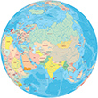
Map of Indian Ocean


Map Indian Ocean


Madagascar


Geographic Guide

Africa

World maps


Map african countries


Australasia


Physical map of the Indian Ocean area (on the right, click to enlarge) made by the U.S. CIA, 2013, with additional text.

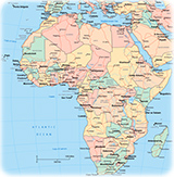
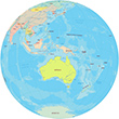
The Indian Ocean is the third-largest of the oceans of the Planet and it is the youngest one. It stretches for more than 10 thousand kilometers, between the southern tip of Africa, at the Cape of Good Hope, and Tasmania, Australia. Asia is to the north and the Southern Ocean is to the south. The Indian Ocean has been known by its present name since at least 1515 when the Latin form Oceanus Orientalis Indicus is attested, named for India, which projects into it.
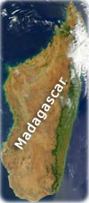
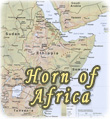
 In the Middle Ages, trade routes to India were dominated by the Arabs, but at the beginning of the 16th century the Portuguese expelled the Arabs and began to dominate trade throughout the region bordering the Indian Ocean and the Persian Gulf. By the late 16th century, the Dutch, French and English began to explore trade in the region.


Asia


Goa India


Asia globe political


See Cathedral of Goa, built in 1523 in Goa, Portuguese India (post card by N.W. Siqueira, Goa).


Mercator World


South Atlantic Ocean map


Maps


Map Horn Africa


Copyright © Geographic Guide - Travel and Maps, African Continent.


Map of Indian Ocean


Africa Maps