Images of South America
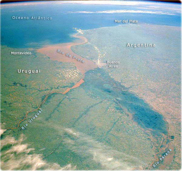
Rio de la Plata, Argentina (image above). In addition to the Atlantic Ocean, three important water features of Argentina’s central east coast are apparent in this photograph: the Paraná River (South America’s second largest drainage basin), the southward-flowing Uruguay River, and the muddy Rio de la Plata. Paraná’s delta, measuring more than 275 km in length and averaging 50 km in width, appears dark green in this northwest-southeast orientation. The delta is composed of numerous meandering and interbraided streams and channels that make it subject to occasional severe flooding. The silt-laden main watercourse is observable at various points within this flood prone area. The southward-flowing Uruguay River, which has a very high level of sediment, passes east of the mouth of the Paraná River delta. The merging of these two rivers with their high levels of silt almost always produces an extremely muddy Rio de la Plata. The interfluvial area of the Paraná and Uruguay Rivers, known as the Mesopotamia of South America, is composed of floodplain and gently rolling, well-drained land. Montevideo, capital of Uruguay near the northeast limit of the Rio de la Plata, and Buenos Aires, capital of Argentina at the southern end of the Paraná River delta, are not identifiable on this scale (NASA 1990).
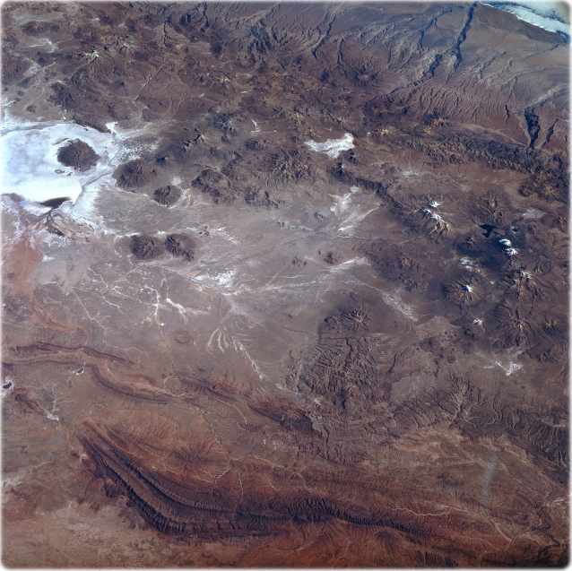
Lake Coipasa, Bolivia (NASA, June 1996). The most obvious landform in this view of the Altiplano in southwest Bolivia is the highly reflective salt flat, Salar de Coipasa (upper left). There is a dendritic drainage pattern that connects to intermittently flowing stream channels north of the Salar de Coipasa. The darker, semi-circular features are volcanoes that generally trend north-south. The maximum elevation of the volcano, located within Salar de Coipasa, is 4922 meters above sea level, while the elevation of the dry lake is 3653 meters. A series of paralleling folded mountains are visible near the bottom of the image.


The beautiful beach of Piatã, in Bahia, Brazil. According to CNN, Bahia is one of the 10 best places to travel in South America.
|
About the Geographic Guide - Travel South America. |
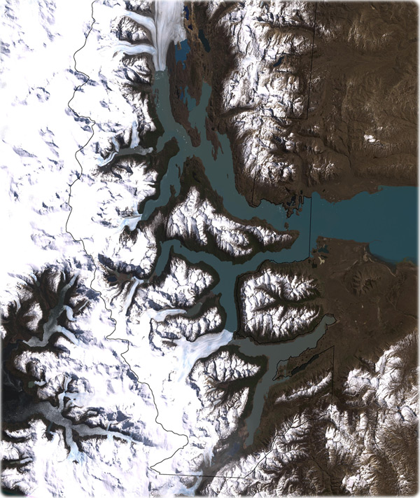
Los Glaciares National Park, Argentina (image right). The park encompasses mountains, lakes, forests, and glaciers in the Andes along the Chilean border. The United Nations Educational, Scientific and Cultural Organization declared this area a World Heritage Site in 1981. The park provides a home for guanacos, pumas, foxes, and many bird and fish species.
This Landsat image, acquired on October 14, 2001, shows the southern portion of Los Glaciares National Park. Snow and ice are white, water is blue, and bare or thinly vegetated ground is brown. Over time, glacial melt has formed two lakes in this park: Lago Viedma and Lago Argentino (shown in this image). Lago Argentino has an unusual feature: the Perito Moreno Glacier, appearing in more detail in this astronaut photograph, periodically dissects the lake. As the glacier advances, it cuts off one side of the lake, known as Brazo Rico, from the other side. Over time, the water level of Brazo Rico rises enough to break off the tip of the glacier. After rupturing the glacier, Brazo Rico dumps its excess water into the other side of the lake. Water pressure ruptures the Perito Moreno Glacier every four or five years on average, although the pattern of ruptures is irregular.
Besides the periodic ruptures of the Perito Moreno Glacier, the park offers other feasts for the eyes, including the rugged Cerro Torre and Mount Fitz Roy, named for Robert Fitz Roy, who captained the Beagle on Charles Darwin’s famous voyage. These tall, jagged, granite peaks have been shaped by glacial ice, and their extremely steep slopes pose serious challenges for modern mountain climbers (NASA).